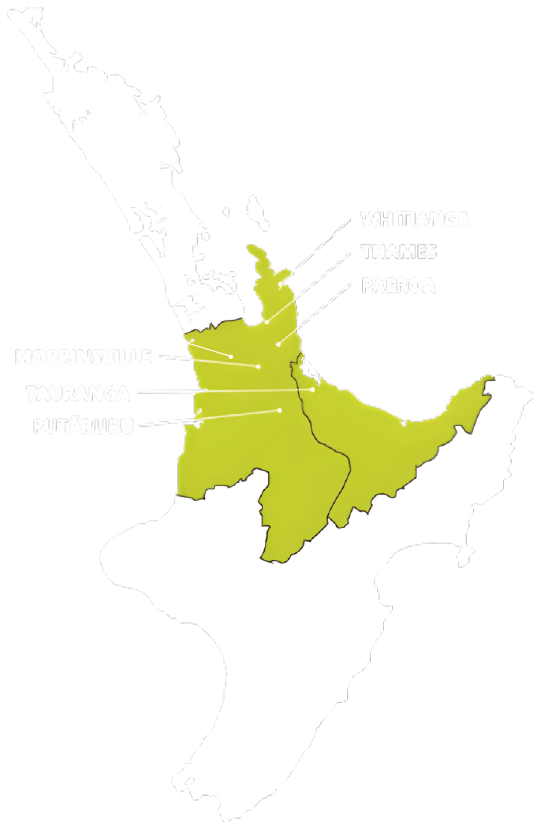
Articles


How can I subdivide my farm during the COVID-19 Coronavirus Lockdown? (Apr 2020)

With the country currently in lockdown, our farmers are still working hard to keep the food supply going which we are all thankful for.  It is this rural primary production that will help pull us through, as always.  We are looking at how we can keep things going for those out there needing to subdivide their land.  Whether you need to pay back some debt or you just have that unproductive paddock, or second house that is just causing you issues but could give a family the start they need, we may be able to help you as we have helped many others in the past.


Well, apart from not being able to put the pegs in the ground where required to, we can do so much to help you out right now.  We have adopted plenty of new technology over the past few years, whilst setting ourselves up to operate remotely in our day to day work when required by an issue such as the Coronavirus Covid-19 lockdown.


So, there is a lot we can do without leaving our office (read ‘home’ at present).  Once you have called and explained your situation and what you are considering doing, we have the on-line tools at our fingertips ready to assist.  From a library of rural aerial photographs through to detailed property ownership records, we have it all.


From the minute we start talking with you, we have a copy of your farm titles on the screen in front of us.  This provides us with the exact size, shape, number of separate titles and other statistics relating to your farm.  For example, this includes restrictions such as right of way easements crossing your property, covenants which might prevent you from doing certain types of development and rights that you may enjoy over other adjoining properties.


From there, we can quickly overlay our maps with recent aerial photography.  Now we can see the whole picture - how your legal boundaries relate to physical features such as roads, houses, access tracks, implement sheds, paddock fences, steams and wetlands.  With all the relevant land information in front of us, we are now up and running. Using our knowledge of the rural subdivision rules, we can then give you a good idea of your farm subdivision possibilities.  From here on, there is even more detail that must be researched and considered.


The next level of information is often provided by your Council, and we have access to that too.  They have a Geographical Information System (GIS or On-line Maps) which often have aerial photos and sometimes farm contours, but also provide records of service connections that they have responsibility for - such as water, and stormwater drains.  These records also provide an indication of potential flooding areas, soil contamination and other hazards that can affect proposed building sites such as potential slipping and liquefaction potential.  Council’s web site also contains details of the current subdivision rules, land use rules and building rules.  Also on-line is council’s development code which provides specifications for construction of access and drainage which will be required as part of the subdivision process.


We do have to physically look at the property at some point, but we can always take a look at Google Street View and observe the road frontage of your farm from different angles – not significantly different from driving by, in fact.  This informs us of the road access possibilities for new lots as well as safe visibility from a possible entrance position.  And then, if you have the technology, as most people do these days, you can take us on a virtual tour of your farm using Skype or WhatsApp. Thankfully, there is not much that can’t be achieved remotely these days.


As you see, there is a lot that we can do to advise you without getting out of our seat, thanks to our investment in this technology.  There will often be ‘on site’ testing required prior to lodging a resource consent application with the local council, but we will be all set up for this without leaving the office.  Currently Councils are advising us that ‘on site’ inspections may be possible with video, as they adapt to the new normal.

Trig points and topographical surveying
theodolite - traditional land surveying equipment
Surveying Services Subdivision Planning Team Vehicle
Mt Maunganui Land Surveying